
Building the world's most advanced dMRV for rice farming

Rice farming emits methane at levels comparable to the global aviation industry, yet remains vastly under-addressed in climate strategies. As a crop that feeds over half the world’s population and consumes 30% of global freshwater resources, rice is both essential yet resource and emissions-intensive. But traditional emissions tracking tools—built for temperate crops like corn and soy—simply don’t reflect the complex, water-logged, and highly variable nature of rice systems.
At Mitti Labs, we’ve built a rice-specific digital Monitoring, Reporting, and Verification (dMRV) system designed from the ground up to handle this complexity. Our platform integrates satellite data, process-based modeling, and ground-level intelligence to deliver highly accurate emissions tracking across rice landscapes. The result: high-integrity, verifiable carbon credits that reflect real climate impact.
Backed by a team of 15 full-time scientists across agronomy, machine learning, remote sensing, and crop modeling, our work combines scientific rigor with deep field insight. We’re not just building tools—we’re enabling scalable, measurable action on one of the world’s most urgent and overlooked methane challenges.
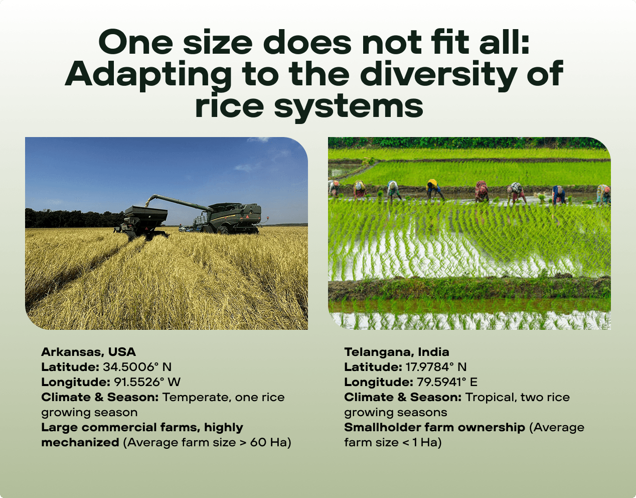
One size does not fit all
In many monitoring frameworks, emissions from rice are calculated using generalized emissions factors or what's known in climate accounting as "Tier 1" methodologies. These apply a single average value to all rice fields in a given country or region, assuming uniformity in climate, soil, water use, and farmer behavior. This approach fails to capture the nuance and diversity of real-world practices and leads to significant inaccuracies in emissions reporting. Without a system that can accurately quantify these differences, it is impossible to generate credits with high integrity or to reward farmers for their efforts to reduce emissions.
But generic models—often designed for large-scale, mechanized farming in temperate climates—cannot be reliably applied to smallholder rice farms in Asia or even accurately capture variability across commercial rice operations across the Midsouth United States. Recognizing this gap, Mitti Labs built a rice-specific dMRV system capable of accurately tracking management practices and quantifying greenhouse gas (GHG) emissions across vastly different rice landscapes.
A three-layered technology stack
At Mitti Labs, scientific precision is the cornerstone of our approach. Our technology architecture has been purpose-built from the ground up—designed not only to reflect the ecological complexity of rice systems but also to elevate standards for carbon market credibility.
Unlike many off-the-shelf MRV tools that rely on broad estimations and average emissions factors, our platform is fundamentally grounded in first principles, advanced environmental modeling, and a deep integration of multiple data layers.
1. Ground-level data collection & landscape experiments
Before any intervention takes place, Mitti Labs conducts rigorous, field-by-field, treatment vs control experiments and data collection processes to establish a detailed environmental and management baseline. Using smartphone-based tools & IoT devices, our field teams gather key information directly from farmers, including:
Field boundaries and land ownership details
Planting and harvesting schedules (crop calendars)
Seeding, irrigation, residue, and nutrient management practices
Historical land use and local-to-landscape farming behaviors
This data is scientifically critical. By digitizing traditional “farmer log books” and installing multiple layers of QAQC, we are able to confidently assess current practices. Our tech-stack allows us to deploy across individual fields and an entire landscape, measure variability between fields and regions, and evaluate the impacts of any proposed intervention.
“Each farm is different and we help optimize every field for yield and sustainability to benefit the grower”, said Mitti Labs co-founder Nathan Torbick.
This baseline serves two important functions:
It ensures additionality—by demonstrating that a Climate-smart practice represents a real change from business-as-usual.
It enables high-integrity carbon quantification, because emissions reductions can be verified when compared to a robust, site-specific starting point and are fit for purpose.
In short, this ground-level intelligence provides the foundation for both scientific rigor and trust in the carbon outcomes we generate.
2. Advanced satellite observation and physical retrieval
Unlike conventional remote sensing approaches that rely on indirect proxies or generalized indices, Mitti Labs employs physical retrievals of field attributes—a scientifically grounded technique that measures specific biophysical variables using multi-frequency satellite synthetic aperture radar data. These biogeophysical attributes include inundation frequency and duration, soil moisture levels, plant height and biomass, burn type, and residue amount.
This approach enables us to classify field-level practices—such as irrigation, seeding, and tillage—not by inferring them from abstract correlations, but by observing their physical characteristics at field scale and across the landscape. In practical terms, this allows us to determine with high precision how often a field is flooded, how long it remains under water, if a dry downs occur, and how crops develop over time—all of which are critical drivers of methane emissions in rice systems.
Our system processes terabytes of satellite imagery, incorporating multiple radar sensors and daily optical bands to deliver detailed, temporally consistent insights at scale. At the finest spatial resolution we use 25 cm X-band, which helps unlock accurate tracking of small-holder scales, and combine with time-series, quad pol L-band that penetrates canopies to track irrigation features like inundation frequency.
This rigorous, physics-based approach stands in contrast to the “kitchen sink” models that simply aggregate variables into black-box predictions without transparency or transferability. By extracting physical attributes directly, we ensure that our emissions monitoring is not only accurate but physically meaningful, reproducible, and scalable across diverse rice landscapes. This helps farmers make practical decisions and generates high integrity credits.
3. Process-based modeling and AI integration
At the core of Mitti Labs’ technology stack is our process-based model—a scientifically grounded ecophysiological simulation that tracks how carbon and nitrogen move through rice ecosystems. This model captures key biogeochemical processes such as methane generation, soil respiration, and nutrient cycling, all of which are central to understanding and quantifying greenhouse gas (GHG) emissions from rice cultivation. By innovating alongside USDA ARS and IRRI, we ensure the best available science is applied.
What makes our approach distinct is how we execute landscape experiments across agro-climatic zones with real-world farms and combine our satellite physical retrievals and IoT ground truth using Geo-Artificial Intelligence. Geo-AI lets us go beyond traditional empirical modeling or static satellite observations to drive parameterization. Instead, we use Geo-AI to dynamically fuse satellite physical retrievals with process simulations, allowing the digital twin to “learn” from new data, improve continuously, and generate increasingly precise insights over time.
This unlocks a new frontier in agricultural carbon monitoring: real-time, precise field scale analytics, and forward-looking forecasting. Rather than waiting until the end of a growing season to assess emissions reductions, we are building tools that help farmers optimize practices in-season. For example, based on live data, our models recommend when a farmer should begin field drainage to maximize methane reduction without sacrificing yield—enabling better environmental outcomes, more farmer profit, and higher-quality carbon credits.
By combining robust science with adaptive intelligence, Mitti Labs’ platform becomes not just a monitoring tool, but a strategic decision support system for Climate-smart agriculture.

Why this work matters
Methane is one of the most potent and under-addressed greenhouse gases—rice farming alone accounts for up to 12% of global methane emissions. Yet the sector remains overlooked and poorly measured.
At Mitti Labs, we’re changing that. Our rice-specific dMRV system combines science, technology, and local insight to bring unprecedented accuracy and credibility to agricultural climate action.
As methane reduction becomes a global priority, tools like ours will be essential. We're making emissions measurable, credits verifiable, and impact real—at scale.
Offset your emissions with high-quality carbon credits
Previous article

Next article

Start your Methane Journey
Copyright 2025 © MittiLabs. All rights reserved.